Williston evaluates its current bicycle and pedestrian infrastructure and has a plan, including adequate funding to upgrade the system over time.
Chapter 10
Transportation
Introduction
Mobility in Williston and to points beyond is critical to all who live, work, shop, and recreate here. Public and private infrastructure that supports the mobility of people and goods has significant and wide-ranging impacts on the Town and its people. Transportation infrastructure is probably the most costly and complicated type of asset for the town to construct, upgrade, and connect. At the same time, the way roads, bike paths, sidewalks, and transit systems are placed in our Town shapes our land use planning and the development pressures it attempts to address. Conversely, how we develop our land influences the opportunity to provide multi-modal choices to residents and visitors.
Given the great expense, complexity, and time related to making changes to our transportation infrastructure, and the near- permanence of those decisions once they have been implemented, we must make careful decisions about how to proceed. In response to extensive feedback from the public, this chapter proposes a significant focus on expanding and enhancing mobility in Williston for modes of transportation that do not require the use of an individually owned vehicle. Think walking, bicycling, taking the bus, and using ride-share or taxi services. While this chapter acknowledges that individuals choosing to drive alone will likely continue to make up most of the transportation in Town, it also recognizes that the choice to do so has been heavily shaped by a lack of other transportation options.
Safe space to walk and bike does not exist along many of Williston's roads. Bike paths and sidewalks sometimes end abruptly, do not connect to one another, or are interrupted by unsignalized crossings of busy roads. Bus service is limited and infrequent and only covers a small geographic area in Town. A complete and well-rounded transportation strategy will enable the town to facilitate the movement of people and goods, protect public safety, promote healthy lifestyles, and foster community building through the town.
This chapter lays out a set of goals, strategies, and actions intended to expand transportation options to all in Williston.
Goals: In 2050, Williston is...
»»
Livable
...because its transportation infrastructure is aesthetically pleasing and safe to use (street trees, adequate space for all users). Williston's transportation system provides opportunities to combine exercise and social interaction with going places. Williston implements land use policies that support connectivity, active transportation, and high-density mixed-use development. This promotes safe and convenient physical activity opportunities, reduces injuries associated with motor vehicle crashes, and minimizes human exposure to air and noise pollution and the associated adverse health impacts. These policies also enhance access to medical care, essential health and human services, nutritious foods, employment, and social connection.¹
»»
Resilient
...because Williston's transportation system is able to withstand disruptions from weather events, maintenance activities, power outages, or crashes by providing more than one mode of transportation and more than one route for people to get where they are going. Williston proactively maintains its transportation system (roads, bridges, culverts, paths and sidewalks) in a manner that promotes sustainability and useability. This includes both roads and active transportation routes (paths and sidewalks), long term and day-to-day maintenance such as plowing.
»»
Equitable
...because Williston has transportation infrastructure and systems that allow all people to get where they need and want to go safely and efficiently. The transportation needs of those who do not have access to a private car are met with adequate alternatives including walking, biking, public transportation, rideshare, and special needs transportation. A robust, multifaceted transportation system helps reduce transportation costs, allowing households to allocate more funds to essential needs like food, medical care, childcare, and utility bills, while also enabling them to save and build wealth. A broader variety of transportation modes support mobility independence, particularly among non-drivers, older adults, and individuals with disabilities, and empowers all community members to meet their needs.
Three Things to Know
1
WILLISTON'S PEOPLE MOSTLY GET AROUND BY DRIVING ALONE.
Almost 90% of respondents to the Williston 2050 survey said that they typically get around Town by driving alone.
2
WILLISTON'S PEOPLE VALUE THE ALTERNATIVES TO DRIVING ALONE THAT ARE AVAILABLE.
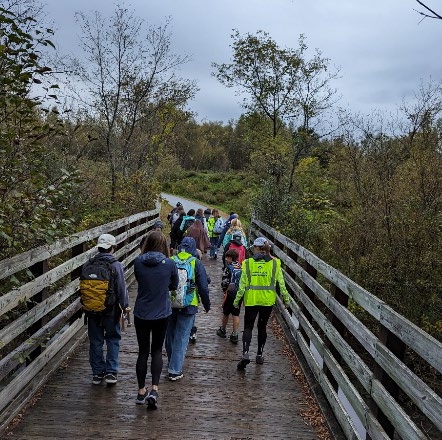
People in Williston value the multi-use path system in Town and see access to it and the town's sidewalks as one of the major positives of living here.
3
WILLISTON'S TRANSPORTATION INFRASTRUCTURE, PARTICULARLY INTERSTATE 89 AND EXIT 12, HAVE SHAPED PAST DEVELOPMENT AND FUTURE DEVELOPMENT PRESSURE IN TOWN.
Taft Corners largely developed because of the accessibility to the region created by interstate 89. Transportation Infrastructure that makes Williston easy to get to from nearby population centers will continue to shape desired development in Town into the future.
Three Things Public Engagement Told Us
1
WILLISTON'S PEOPLE WANT EXPANDED BICYCLE AND PEDESTRIAN INFRASTRUCTURE IN TOWN.
While Williston has some bike paths and sidewalks, residents have identified gaps in connectivity and safety concerns. They want safer routes for cycling, including more bike lanes on main roads and measures to reduce traffic speeds. Improved pedestrian infrastructure, such as wider sidewalks, better lighting, and more crosswalks, are also desired. 40% of respondents in the Williston 2050 survey said that Williston's bike and pedestrian facilities are a strength of the town. However, 27% of people said that insufficient bike and pedestrian facilities were the biggest transportation challenge. 66% of people think that Williston should fund and support the building of new paths and sidewalks, even if it increases taxes and people think that bike lanes and paths are the best way to encourage forms of transportation besides single occupancy vehicles.
2
WILLISTON'S PEOPLE WANT BETTER AND MORE FREQUENT PUBLIC TRANSPORTATION
Williston's people expressed that the current public transportation system is lacking, with limited routes, infrequent service, and slow speeds. This makes it difficult for people who rely on public transit for work, errands, and other activities. There is a strong desire for improved bus service with expanded routes and increased frequency.
3
WILLISTON'S PEOPLE ARE CONCERNED ABOUT TRAFFIC CONGESTION.
Traffic congestion, particularly during peak hours, is a significant concern. Key areas like Route 2A, Williston Road, and Taft Corners experience heavy traffic at times, leading to delays and frustration for commuters and those who live in neighborhoods accessed by these roads.
Recent Transportation History in Williston
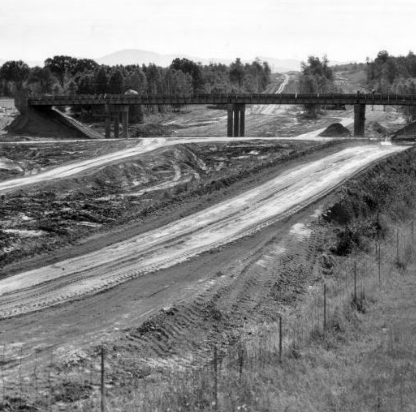
While some of the roads in Williston do follow ancient pathways that date before the use of the passenger car, much of Williston's landscape has been shaped by a single major event- the construction of Interstate 89 and Exit 12, which made it convenient for shoppers from around the county and the state to come to Williston, and for Willistonians to live in the Town while commuting to work elsewhere. The development of Taft Corners as a suburban shopping center followed, with the first proposals for malls and shopping centers in the area arriving within a decade of the completion of the highway.
Almost as soon as Exit 12 was open to travel, Williston began to prepare for another major highway in Town, the Circumferential Highway, or "Circ," which would have connected Interstate 89 to Route 2 between Taft Corners and the Village, Mountain View Road, and Route 289 in Essex- and eventually all the way to Burlington via a "ring road." The 2011 Williston Comprehensive Plan had been almost entirely drafted and approved when then-governor Peter Shumlin held a press conference alongside Interstate 89 to announce that, after 40 years, tens of millions of dollars in planning, and several expensive lawsuits, the Circumferential Highway would not be built. Williston pivoted over the next few years, participating in a "Circ Alternatives" process that identified projects that could relieve congestion in Town in other ways, by making improvements to existing roads and intersections and by providing infrastructure for walkers and cyclists so alternatives to driving would be more available.
Circumferential Highway Alternatives projects for Williston include:
- I-89 Exit 12 Interchange Stage I-IV Improvements
- Stage 1: New Shared Use Path under Interstate & New VT2A Lane from Marshall Ave to I-89 NB Ramp (Completed in 2022)
- Stage 2: New Grid Streets and At Grade Intersection on VT2A between I-89 & Marshall Ave
- Stage 3: Diverging Diamond Interchange Improvements
- Stage 4: VT 2A Boulevard Upgrade from Grid St Intersection to Taft Corners
- Industrial Ave/Mountain View Rd/VT 2A - Intersection Improvements; New VT 2A Lane to James Brown Dr (In Progress as of 2025)
- New US 2 Taft Corners to Williston Village Shared Use Pathway and Village Sidewalk2 (Planning Ongoing)
- New Mountain View Road and Redmond Rd Ext to IBM Access Rd Shared Shoulder
- New Harvest Lane Taft Corners Sidewalk, VT2A Taft Corners Area Sidewalks/Shared Use Path, VT2A North Gap Path, VT2A South Gap Sidewalk/Path3
To date, one of these alternative projects has been completed, one is in progress, and many of the promised projects are listed further out in the state's Transportation Implementation Plan (TIP), unfunded and with an uncertain completion date.
The Williston-Essex Network Transportation Study (WENTS) built upon the CIRC Alternatives process to develop a set of multimodal strategies, policies, and land use strategies that enhance corridor mobility, improve access to major employment and retail centers, minimize congestion, improve safety, support economic development, and enhance environmental quality within the WENTS area. The study resulted in a set of short- and longer-term multimodal strategies (Implementation Plan) that will help achieve the area's Goals and Objectives.
Scoping study was completed in 2014 and was updated in 2025.
Short/Mid/Long Term Implementation Package of Phase III CIRC Alternative Projects. Chittenden County Regional Planning Commission. Accessed 4/7/2025 at https://www.ccrpcvt.org/wp-content/uploads/2016/01/20131121_PhaseIII_Project_List_Final.pdf.
A Network Implementation Plan was developed that identified specific transportation improvements, by mode, time frame, estimated cost, and lead agency for pursuing those improvements. For more details on this study, read the WENTS Final Report.4
Since the adoption of the 2016 Williston Comprehensive Plan, the Town has made progress and improvements to its transportation system including:
- Completion of the Exit 12 Park and Ride (by Vermont AOT)
- 4-way stop at intersections of Rte. 2/North Williston Rd and North Williston Rd/Mountain View Rd
- Traffic signal and reconfiguration of James Brown Drive/Rte. 2A intersection
- Elimination of the passing lane along Rte. 2 entering the Village
- Painted bicycle lanes along both sides of Rte. 2 from the Village to S. Brownell Rd
- Infill paths/sidewalks
- Route 2A (section in front of Bank North Property) 2018
- Blair Park (in fill around loop to connect to Route 2) 2021
- Williston Road (S. Burlington Town Line/Muddy Brook to Industrial Ave) 2023
- Along Rte. 2A under Interstate (part of a CIRC alternative project)
- Throughout Finney Crossing
- Along Rte. 2 fronting Cottonwood Crossing
- Along Rte. 2 fronting former Robear property to Industrial Ave.
- Adoption of Official Map
- Microtransit Feasibility Study
- Scoping study and conceptual design for Taft Corners Multimodal Hub
- Scoping study and implementation of traffic calming measures on North Williston Rd.
- Road safety audit of Oak Hill Rd.
- Update 2014 Williston Road Multimodal Scoping Study
- Class I Town Highway Study
- Adoption of Taft Corners Form Based Code and Street Specifications.
R.S.G. Transportation, Inc. prepared for Chittenden County Regional Planning Commission. 2014. Williston Essex Network Transportation Study (WENTS) – Final Report. Accessed 4/8/2025 at https://www.ccrpcvt.org/wp-content/uploads/2016/01/WENTS-Final-Report-March2014.pdf.
Action Areas
Taft Corners Grid Streets and Class I Town Highway Reclassification
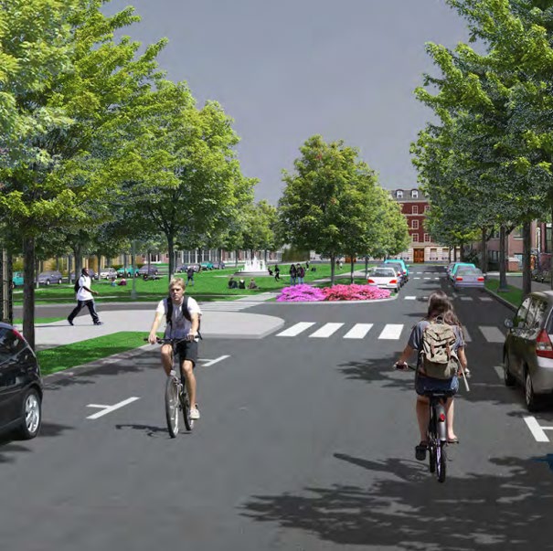
In 2022, Williston adopted the Taft Corners Form Based Code, which envisions and codifies a vibrant mixed-use, urban village in the area surrounding intersection of 2 and 2A. This future for Taft Corners relies on the construction of grid streets to achieve a safe, walkable, livable, area that supports a mix of small businesses, housing, and green space as well as alleviating congestion and collision concerns on the main arteries.
The town is committed to building "Complete Streets" whenever possible. Complete Streets are those that include design features for addressing the needs of all modes of transportation not just vehicles. New transportation facilities should incorporate complete street design principles to the maximum extent possible, and improvements to existing roadways should incorporate facilities for non-motorized transportation users whenever feasible. To that end, the Taft Corners Form Based Code district incorporates street specifications that align with Complete Streets principles.
However, the goals of the town in building these grid streets including the incorporation of Complete Streets design principles, are not compatible with the two highways bisecting it. As early as 1991, Vermont AOT warned that they would not maintain ownership of a road with the number of intersections planned along Route 2A.
Williston is not unique in this respect. The state recognizes that conventional highways running through downtowns can be at odds with the needs of the individual towns that they run through and offers the Class 1 Town Highway reclassification process, wherein the town takes ownership for a segment of road, as a solution.
"Reclassification can have benefits for both the municipality and VTrans. It provides more flexibility to the municipality for streetscape design, traffic calming measures, placement of crosswalks, on-street parking, coordination of maintenance activities and the municipality receives annual compensation via Town Highway Aid. While at the same time the municipality retains eligibility for most state and federal grant programs. VTrans is relieved of maintaining a section of road that may require customized equipment or practices that are beyond the resources of VTrans maintenance staff."5
To make these corridors more pleasant, walkable, and safe as well as support the window-shopping environment of local businesses and gathering places, Williston will need to take these roads over as Class 1 Town Highway or advocate Vermont AOT's policy to be more flexible to support the Town's needs.
Dubois and King, Inc., 2016. Class I Town Highways: Costs and Issues for Vermont Communities Considering Reclassification of State Highways. White Paper prepared for Vermont Agency of Transportation Policy, Planning and Research Bureau. Accessed 4/8/2025 at https://vtrans.vermont.gov/sites/aot/files/planning/documents/planning/Class%20I%20Town%20Highways%20White%20Paper.pdf.
Town Path and Sidewalk Network
A majority of the responses to Williston's public engagement process in Fall 2023 were about bike lanes, sidewalks, and bus routes. Some participants noted that a car is essentially required, and some of those said that Williston should not invest in this area to attempt to change that. A few participants commented about micro-transit.
- 40% of respondents stated that they think Williston's bike and pedestrian facilities are a strength of the town. Visiting the walking path behind Allen Brook School on any given day, you will see numerous users out for a walk, jog, or rollerblade.
- 89% of people typically drive alone when getting around Williston. While vehicle transportation has taken and will continue to take the largest share of our infrastructure budget, there is steady and vocal support for other options.
- Nearly 50% of respondents noted that improving bike and pedestrian facilities is a top town priority to addressing transportation challenges. Not only do people feel that the town needs more connected bike lanes and walking paths, but the town also needs to address bike and pedestrian safety through slower traffic speeds, better marked crosswalks, and street lighting.
- 55% of 254 respondents think that bike lanes and paths are the best way to encourage forms of transportation besides single occupancy vehicles.
- 66% of people think that Williston should fund and support the building of new paths and sidewalks, even if it increases taxes.
• Most of the areas that people feel unsafe walking and biking are along major roads6
A town-wide network of paths reduces congestion on our roads for local trips and provides opportunities for recreation and connection. When combined with bicycle infrastructure, public transportation, and first/last mile connection, expanded pedestrian pathways improve job and housing options without the need to own a car. This has significant social benefits for low-income households, single-parent and younger homes, individuals with disabilities, and non-white individuals, who are less likely to own cars.7
The Official Map shows existing trails and paths and those proposed. The Official Map was developed through a public process and adopted in 2022. Per 24 V.S.A. § 4421, the intent of an Official Map is to identify the location of future municipal utility and facility improvements, such as road or recreational path rights-of-way, parkland, utility rights-of-way, and other public improvements, in order to provide the opportunity for the community to acquire land identified for public improvements prior to development for other use.8
Williston last took out a bond for sidewalks in 2004, and alongside that has relied on developers to build sidewalks and paths as part of their projects. This has resulted in gaps – sidewalks that go to nowhere with no plans to be connected, primarily due to lack of funding.
Town of Williston, Vermont, 2024. Town Plan Engagement Insights Report. https://www.town.williston.vt.us/vertical/sites/%7BF506B13C-605B-4878-8062-87E5927E49F0%7D/uploads/Williston_2050_Engagement_Insights_Report_Final_April_2024.pdf. Accessed April 29, 2024.
Volker, J. M. B., & Handy, S. (2021). Economic impacts on local businesses of investments in bicycle and pedestrian infrastructure: a review of the evidence. Transport Reviews, 41(4), 401–431. Accessed 4/8/2025 at https://doi.org/10.1080/01441647.2021.1912849.
Vermont Statutes. 24 V.S.A. § 4421. Official map. Accessed 4/8/2025 at https://legislature.vermont.gov/statutes/section/24/117/04421.
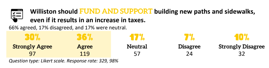
Figure 1: Summary of responses to online survey question about funding new paths and sidewalks.
Surrounding communities such as South Burlington have utilized a Penny for Paths program to ensure that these projects get consistent funding, both to increase pedestrian safety and close gaps in existing networks. A typical mechanism may be a dedicated 1 cent on the tax rate, such that a $300,000 property would pay $30 into this fund.
Public Transit
Williston currently has limited, fixed-route bus service provided by the Green Mountain Transit (GMT) and on-demand special transportation services provided by the Special Services Transportation Agency (SSTA). Map 8 – Existing Transportation Network shows the present bus routes. The #1 Williston/Burlington route runs every 20 minutes from 6:00 am to 11:10 pm Monday-Friday and on Saturday every 30 minutes from 7:40 am to 7:40 pm with less frequent service in the early morning and late evening hours. Sunday service runs about every 45 minutes from 8:40 am to 7:10 pm. The #10 Williston/Essex route runs Monday-Friday, 7:00 am to 6:15 pm with trips spaced 75 minutes apart.9
Route #1 (Williston/Burlington) is one of GMT's most successful routes and serves over 55,000 trips per month. Route 1 ridership had returned to pre-COVID levels by January of 2023. Currently, Route #10 (Williston/Essex) delivers around 1,800 trips per month.10
Some service reductions have been implemented since the last Town Plan was written. The Williston Village route was discontinued in 2019 due to low ridership (about 1,000 trips/month). In GMT's efforts to manage a near-term financial cliff due to the conclusion of covid-relief funds, several route adjustments are being made. This includes the elimination of the Saturday run of the #10 Williston/Essex route and less frequent service for the #1 Williston/Burlington route.11
GMT also provides on demand service for people eligible for special transportation services. In FY 2024 1,795 trips were provided for the Older & Disabled Transportation program in Williston.
Recently Williston has begun to explore microtransit as an option to supplement fixed route bus service and provide a locally focused public transportation option. Microtransit, also known as "on-demand transit," is a form of public transit that features flexible routing and flexible scheduling of vehicles. Passengers must request a trip, and this is most commonly done using a smartphone application. On-demand microtransit services match passenger demand (trips) with supply (vehicles) to improve service quality and extend the reach of the transit system. Passengers who live or work beyond walking distance from fixed-route bus stops can use on-demand microtransit to bridge the "first-and-last-mile" gap to reach the longer-distance service. In lower density areas on-demand microtransit's primary application is to improve mobility by offering high-quality service where fixed-route buses cannot operate efficiently.12
In 2023, Williston engaged the services of Via Mobility to complete a Microtransit Feasibility Study. The Study found that Williston is suitable for a microtransit service, and that the community would benefit from additional transportation options. While the Town is served by fixed routes, most residents live beyond walking distance of stops, and there are no locally focused options open to the general public. Residents would likely use microtransit for errand-running trips, and for connection to fixed routes, llowing community members to meet their daily needs without a personal vehicle. This will benefit those without access to personal cars, and those who would prefer to travel via transit and on foot, making for a more livable community where everyone has access to transit service. The Town should continue to pursue avenues for microtransit service.
Green Mountain Transit schedules, accessed 4/8/2025 at https://ridegmt.com/gmt-schedules/.
Green Mountain Transit Performance Dashboard. Accessed 4/8/2025 at https://ridegmt.com/performance-dashboard/.
Green Mountain Transit. Town of Williston 2024 Annual Report. Accessed 4/8/2025 at https://www.town.williston.vt.us/vertical/sites/%7BF506B13C-605B-4878-8062-87E5927E49F0%7D/uploads/2024_Annual_Town_Report.pdf.
Via Mobility, LLC., 2023. Williston Microtransit Study Final Report. Accessed 4/8/2025 at https://www.town.williston.vt.us/vertical/sites/%7BF506B13C-605B-4878-8062-87E5927E49F0%7D/uploads/Williston_Microtransit_Study_Final_Report_-_v2.pdf.
Objectives, Strategies and Actions
Objectives
10.A
10.B
Gaps in the existing multi-use path and sidewalk system are connected with new sidewalks and paths rapidly to create a more interconnected network.
10.C
Existing sidewalks and paths are maintained and enhanced where needed.
10.D
Bike lanes and space for walking are added to roads where cyclists and walkers feel unsafe.
10.E
Transit that is frequent, affordable, and fast enough to compete with driving alone, is available to most people in Williston.
10.F
Vehicle congestion on Williston's roads is monitored and intersection and street improvements are made when congestion is predicted to create a safety or accessibility issue. Congestion mitigation is focused on vehicle throughput as opposed to vehicle speed.
Strategies
10.1
Create a Bicycle and Pedestrian Plan as an addendum to the Comprehensive Plan.
10.1.1
Evaluate the current Bicycle and Pedestrian network in Williston and identify gaps and places in town where bicycle and pedestrian infrastructure is desired.
10.1.2
Prioritize 'gap closing' bicycle and pedestrian infrastructure projects based on Williston's 'Livable, Resilient, Equitable' vision as stated in the Comprehensive Plan.
10.1.3
Evaluate and rank projects called for by the Plan in terms of cost, effectiveness, relative difficulty to implement, and population served.
10.1.4
Review the Plan on an annual basis to assess progress towards goals. Consider adopting a few key performance indicators to facilitate this periodic assessment.
10.2
Use the Comprehensive Bicycle and Pedestrian Plan to pursue scoping, design, and construction of the projects it calls for.
10.2.1
Develop bicycle and pedestrian projects using the Chittenden County Unified Work Program (CCRPC UPWP) annual process to request technical assistance.
10.2.2
Partner with Local Motion to seek out Federal and State grant opportunities to fund bike and pedestrian paths.
10.2.3
Fund the appropriate local match for these scoping and design efforts in the Planning Department Operating budget.
10.3
Advance the Williston Road Multimodal Path from feasibility scoping through design to construction. This project has much community support and should be advanced.
10.3.1
Develop further scoping to identify constraints such as wetlands and archaeological resources. Utilize the Chittenden County Unified Work Program (CCRPC UPWP) to fund this.
10.3.2
Fund the complete design and construction of the path. Procure local match through a combination of bond and impact fees.
10.4
Evaluate ways to adequately fund the more rapid buildout of needed bicycle and pedestrian facilities.
10.4.1
Prioritize the development of a fixed funding source such as 'penny on the rate' style ballot question on a Town Meeting Ballot to request Williston voters dedicate funds to bicycle and pedestrian infrastructure.
10.4.2
Evaluate projects that can be funded using the Tax Increment Financing tool available to Vermont municipalities.
10.4.3
Evaluate the feasibility of a new bond for bicycle and pedestrian facilities.
10.5
Enhance in the viability of transit in Williston. Improve public transit so it better meets the needs of people who work and shop in Taft Corners. Collaborate with Green Mountain Transit to ensure that transit is an attractive option for all people travelling to and from Williston: workers, shoppers, and residents alike.
10.5.1
Support and advocate for frequent, rapid transit service that meets the needs of people in Williston and is a viable alternative to driving. Fund Green Mountain Transit so it can provide transit that is frequent and rapid enough to provide a viable alternative to driving.
10.5.2
Evaluate possibilities for transit facilities that improve the transit rider experience and allow transit users to switch modes (biking to or driving and parking at a transit center, for example).
10.5.3
Continue to evaluate options for microtransit or 'on-demand' service in Williston.
10.5.4
Develop advocacy plan for direct transit routes in Williston that support frequency of service.
10.6
Build the 'grid streets' in Taft Corners to distribute vehicle traffic and enhance connectivity.
10.6.1
Maintain the provision of impact fee offsets for the private funding and construction of grid streets.
10.6.2
Implement tax increment financing, special assessment districts, bonding, or other mechanisms to fund grid street construction.
10.6.3
Evaluate the possibility of taking portions of Route 2 and/or Route 2A as Class I Town Highways so they can be reconfigured to be more bicycle and pedestrian friendly and be configured to a design that better serves their function as 'Main Streets.'
10.7
Re-evaluate the Transportation Impact Fee and Impact Fee Project List.
10.7.1
Evaluate the transportation Impact Fee in light of rising construction costs and predicted development to ensure new development pays its 'fair share' to mitigate the new traffic it creates.
10.7.2
Evaluate the impact of the transportation impact fee on infill, redevelopment and the creation of new housing to ensure desirable new development is not impeded by the fee.
10.8
Strengthen standards for access, connectivity, sidewalks, multi-use path, and trail connections in all zoning districts.
10.8.1
Develop a consistent, quantitative standard for when sidewalk or path construction is required and when an easement alone is sufficient.
10.8.2
Evaluate ways of incentivizing and requiring path and trail connections without the Growth Management scoring system.
10.8.3
Maintain requirements for safe and convenient short- and long-term bicycle storage and end-of-trip facilities for new development and for amendments to existing development when appropriate.
10.8.4
Maintain policy for consolidated driveway access on arterials and collector roads and the build out of a grid-street network.
10.8.5
Evaluate and modify the number of units and intensity of development served by a single point of access, driveway, and loop road.
10.8.6
Evaluate the Public Works Specifications to provide for street and right-of-way design that prioritizes pedestrians and cyclists and slower vehicle speeds for roads serving residential and mixed-use areas.
10.9
Create a 'park-once' environment in Taft Corners to reduce vehicular traffic and more effectively utilize the land area.
10.9.1
Develop bylaw amendments to reduce or eliminate parking minimums and require shared parking instead.
10.9.2
Evaluate pedestrian connections between parking locations and destinations. Update Williston's Official Map to identify and prioritize the construction of 'missing link' pedestrian connections.
10.9.3
Develop public facilities that enhance transit, bicycling, and walking in Taft Corners and beyond; such as public benches, a multimodal hub at Maple tree Place, and public bicycle racks where none are currently available.
10.10
Design and build new Taft Corners streets for slow-moving traffic and to accommodate bicyclists and pedestrians.
10.10.1
Evaluate the feasibility of allowing or requiring 10-foot-wide travel lanes in some or all of the new Street Specifications that were adopted in 2022 as part of the Taft Corners Form-Based Code, many of which allow for 11- or 10-foot-wide travel lanes.
10.10.2
Evaluate the Form-based Code Street Specifications Map to ensure a complete bicycle network will be created as these streets are built over time. Ensure where possible that all streets that provide an off-street cycle track are connected to one another.