Williston's local zoning meets or exceeds current Act 250 standards for archeological resources review in the development review process in ways that balance best practices with other land use goals.
Chapter 3
Cultural Resources And Archaeology
Introduction
The idea of 'Vermont' brings to mind a particular iconic landscape: quaint rural villages with churches and town halls surrounded by rolling landscapes of farms, barns, and mills. This image is rooted in 19th century economic practices, a particular agrarian culture and, for the most part, existed prior to the automobile. The image is not that of the 1950s, nor is it the 1790s. It was the tail end of the sheep industry and height of the dairy industry. The imagined landscape is deeply meaningful to what is now named Vermont and part of our shared identity – but it is not the full story.
Indigenous people have been residing here and managing the landscape for about 10,000 years, long before European settlers displaced Native groups and started sheep and dairy farms. Indigenous livelihoods make use of local topography, waterways, wildlife corridors, and plants in ways that are not always apparent on the surface of the land to observers. However, Indigenous material culture is embedded in the landscape, whether as buried artifacts or remnants of settlement patterns and walking trails.
Archeology uncovers the story of Vermont's history before it was "Vermont."
The rural village settlement pattern permeates throughout our culture today: from corporate logos to family stories passed down through generations. It is important to remember our history – all history – but more so it is important to stay cognizant and aware of its context and our biases. For example, the beloved agricultural industry has an impact on the health of the natural environment and waterways. Crop fields and manure waste management in flood plains impair vulnerable riverbanks and waterways. Rural lifestyles are ever more exclusive as the costs to develop and reside in low-density patterns rise and are increasingly unattainable for the average household.
Goals: In 2050, Williston is...
»»
Livable
...because its people feel a connection to its past. The presence of archaeological and cultural resources reminds all that we are not the first ones here, nor will we be the last.
»»
Resilient
...because its past is visible, protected, and celebrated. Understanding how people lived in the past - socially, culturally, economically and ecologically – informs how we operate and evolve into the future.
»»
Equitable
...because archaeological and cultural resources, when protected and sustained, provide vital connections for those whose roots extend into the deep past of this land.
Three Things to Know
1
WILLISTON'S ZONING DOESN'T PROTECT ARCHEOLOGICAL RESOURCES
There are no local protections for archaeological resources. Conducting archaeology review in conjunction with development review is costly and complex. Known archaeology sites in Williston are mostly at sites where studies have been conducted as part of the state or federal permitting processes.
2
WILLISTON'S CULTURAL RESOURCES ENCOMPASS MANY PLACES, THINGS, PEOPLE, AND PRACTICES
The definition¹ of cultural resources is extremely broad: from places and intangible cultural practices to artifacts and objects. All are present in Williston.
3
WILLISTON CONTAINS PREHISTORIC SETTLEMENT SITES
There are areas of Williston rich in prehistoric settlement sites. Williston contains physical evidence of human habitation of different cultures. ¹ For a definition of "cultural resources," see https://www.nps.gov/dscw/cr-nrhp.htm
Three Things Public Engagement Told Us
1
WILLISTON'S PEOPLE VALUE THE TOWN'S HISTORY
Buildings, artifacts, landscapes and institutions are culturally significant to the Town and Willistonians value them. When people said they valued community in Williston, the presence of these resources was included in their statements.
2
WILLISTON'S PEOPLE VALUE ITS CULTURAL PRACTICES
Ensuring Williston is a place that continues to have cultural practices, like farming, gathering berries, maple sugaring, and hunting is important to the people of Williston.
3
WILLISTON'S PEOPLE ACKNOWLEDGE THAT ITS HISTORY PREDATES EUROPEAN COLONIZATION
Williston's people acknowledge that its history began long before European colonization and value the archaeological resources in Town that contain this evidence.
Williston's Key Archaeological Sites
Exact archaeological site locations are not public records. These irreplaceable cultural resources are protected from public disclosure in order to protect them from scavengers in Vermont State statute (1 VSA Chapter 5, Section 317 [20]). While site specifics are intentionally limited, there is an abundance of public information about these resources.
- Abazimenahanik "Tree Island" (AHH-baah-Zee; Men; ahh; han; eek)
The knoll along the Allen Brook between Allen Brook School and the Williston Fire Station was inhabited seasonally by Native Americans 10,500 years ago. Thousands of primitive (pre-arrow, pre-pottery) artifacts were found when UVM conducted an archaeological dig in advance of the planned and now defunct Williston portion of the Circumferential Highway.
The area was cleared for agriculture in the 1800's. Aerial photos from 1937 show an orchard on part of it and a few ancient apple and pear trees still inhabit the slope north of Allen Brook. By the 1980's it was abandoned as pasture and is now in the early stages of succession from pasture to forest.
This plan is about returning the area primarily to Northern Hardwood Forest but also including existing passive recreation uses from stump circle classrooms to paths to sliding hills, thus the term "forest park." The plan attached here shows the location of Abazimenahanik.
Types of Cultural Resources
Structures
Williston was incorporated in 1763. The oldest standing building in Williston, Vermont is the Giles Chittenden Farmstead, also known as the Giles Chittenden House, built around 1796 by Governor Thomas Chittenden for his son Giles. There are many historic buildings dating from the late 1700s and early 1800s in Williston, with a concentration in the village center and North Williston areas. Some structures, like the Stovepipe Corners Schoolhouse on the Village Green, have been moved from their original locations. Other structures have been demolished, particularly those in the industrial and commercial area on the west side of town.
Archaeological
Williston has a long and rich history of human settlement far predating the last several centuries of European influence. Though the clues are not so easily found and interpreted as those of European settlement, the Williston landscape abounds with evidence of its prehistoric past. To date, almost 100 archeological sites have been documented in Williston spanning the time period from about 9500BC-1600AD. Books and articles have been written about human history and archaeological resources in this region. Though the summaries contained within this Plan are brief, the objectives, strategies and actions recognize that comprehensive informational resources exist beyond this plan and are constantly evolving as new information and cultural interpretations are brought forth.
Museum Objects
The Williston Historical Society displays in the Vermont Room of the Dororthy Alling Memorial Library currently provide the only museum exhibits located in Williston. A few historical objects hang in Town Hall and Stovepipe Corners Schoolhouse. In certain zoning districts, Williston's land use regulations are permissive of museums whether owned by a government institution, non-profit, or private entity.
Cultural Landscapes
A cultural landscape is defined as a geographic area, including both cultural and natural resources and the wildlife or domestic animals therein, associated with a historic event, activity, or person or exhibiting other cultural or aesthetic values. Of the four general kinds, the Historic Vernacular Landscape indicative of the sheep and dairy farming era of Vermont's historic are most prevalent. Williston has many cultural landscapes. For example, deforestation for sheep farming in the 1800s was a cultural landscape that had a physical impact on the environment. While that is not a landscape to replicate in modern society, its impacts are still seen in the health of forests and settlement patterns.
Certified Local Government
Since 1989, Williston has been a Certified Local Government (CLG) – recognizing the town's commitment to preservation through public policy. Williston last received a CLG grant in 1990. The CLG grant allowed the town to develop a preliminary overview of archaeological resources in town, consisting of the mapping of known sites and the development of an archaeological sensitivity map based on environmental parameters. Through this grant, 65 Native American, 92 European American and 5 unspecified archaeological sites were documented. Williston is long overdue for an inventory of historic structures and archaeological resources. The strategies and actions of this plan call for a proactive utilization of the CLG benefits, such as applying for grants.
Since 1989, the Town of Williston has maintained a historic preservation ordinance in one form or another. Since 2009, historical regulations have been contained within the Williston Unified Development Bylaw. These regulations were updated in April 2025 in accordance with the goals and actions of 2018 Village Master Plan (an Appendix to the 2016-2024 Town Plan) to support adaptive reuse and clear, consistent administration of historic preservation principles.
Presently, Williston's land use regulations only protect historic structures in the Village Zoning District, a small land area that represents less than half of all known historic structures. A cluster of historic properties can be found along North Williston Road near the railroad tracks and Winooski River (a former village center during the railroad and mill days). Few Homesteads with farmhouses and barns remain in the rural, industrial, commercial districts throughout Williston with many having been lost to redevelopment. As recognized in the 2018 Village Master Plan, the best plan for preservation is relevance. Historic structures that can be repurposed and respectfully modified are more likely to be economically viable and maintained. Thus, this plan calls for objectives and actions related to historic preservation town-wide, beyond the boundaries of the Village Zoning District.
Objectives, Strategies and Actions
Objectives
3.A
3.B
Historic sites of local importance, such as historic Town Buildings and cultural recreation areas are protected and preserved for future generations. The community is knowledgeable about the human history of land today called Williston and Vermont.
3.C
Historic practices like farming, recreation, hunting and gathering, religious and civic assembly, and others are maintained and sustained by Williston Town policy, both in terms of Town-controlled regulation and how the Town plans for the use of its buildings and lands.
Strategies
3.1
Explore methods beyond development regulations to investigate, document, and/or preserve archaeological resources on private land.
3.1.1
Evaluate the best way to document the likely presence of archaeological resources while protecting information about their location from unauthorized exploration and removal.
3.1.2
Prioritize parcels with likely archaeological resources when considering preservation of land using Environmental Reserve Fund (ERF) monies and the pursuit of grants and other funding sources.
3.2
Protect archeology resources when disturbance or development is proposed.
3.2.1
Evaluate the feasibility of adopting bylaw standards to preserve and protect archeological resources, to avoid or minimize impacts to archaeological sites that may be impacted by development, in balance with other goals.
3.2.2
Evaluate how to require development to limit soil disturbance to the minimum necessary on sites where testing for potential archaeological sites has not been done.
3.2.3
Evaluate the impact of cost and permitting timeframes when considering development standards that protect archaeological resources. Evaluate these impacts before adoption of local regulation.
3.2.5
Evaluate potential impacts to archaeological resources when considering development of trails or other amenities on Town property in partnership with the Vermont Department of Historic Preservation. Recruit an archaeological consultant to conduct research, survey, and excavation if appropriate.
3.3
Improve the visibility and understanding of Indigenous History, Archeological, Cultural Resources in the landscape.
3.3.1
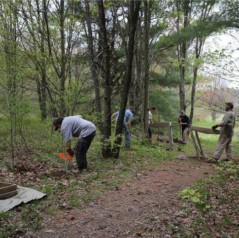
Prioritize Indigenous language when naming public parks and spaces. For example, consider "Abazimenahanik" (Tree Island) as a name if a Country Park is established at Allen Brook School. This park can preserve the archeological resource and enhance public education about this area's early history before European colonization.
3.3.2
Develop a historical resource assessment on municipal structures including Town Hall, Town Hall Annex, and the Old Brick Church to understand their architectural history and modifications over time. Make the findings of this study publicly available through the Town web site and other publications.
3.3.3
Evaluate how to incorporate signage and Indigenous installations on the Town Green and other publicly owned spaces. Develop and execute signage plan to determine the best locations for interpretive signage that promotes knowledge about the presence (past and current) of Indigenous peoples and settlements in Williston. This signage can include landscape and geographical change, early human history to more recent farms and sites.
3.3.4
Develop ways to leverage external funding sources to conduct archaeological surveys or to protect archaeological resources. Williston is a Certified Local Government (CLG) and as such is eligible for grant funding to conduct historic research and documentation related to buildings and archaeology. Williston should use this funding where appropriate.
3.4
Expand and support historic preservation in and beyond the Village Zoning District.
3.4.1
Maintain Certified Local Government (CLG) Status and apply for CLG Funding with local grant match.
3.4.2
Develop an updated town-wide Historic Sites and Structures Inventory.
3.4.3
Evaluate the establishment of a Municipal Historic Preservation Grant or Low/No-Interest Loan Program.
3.4.4
Develop a Historic Preservation Outreach Program led by the CLG Coordinator and HDAC.