The Town will monitor and evaluate the performance of its land use regulations in commercial, industrial, and mixed-use Zoning Districts.
Chapter 16
Residential, Mixed Use And Industrial Land Uses
Introduction
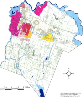
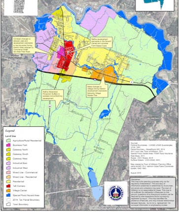
This chapter is about land use in the denser residential, commercial, and industrial zoning districts of Williston. All of the areas addressed in this chapter are either north of interstate 89 or adjacent to Exit 12, and most are south of Mountain View Road as well. Williston's residential, mixed use, and industrial areas include a Village Center, a Growth Center, a suburban residential area, multiple small commercial "gateway" areas, and two industrial areas. Most of the new residential subdivisions and commercial development in Williston happen here.
Williston will be its most resilient when its various parts are in harmony, complementing but not clashing with one another. The development standards contained within Williston's land use regulations will acknowledge inevitable change and ensure that industrial areas built 50 years ago can remain relevant 50 years from now, that open spaces thousands of years old will be open for thousands more, that businesses small and large can adapt to shifting market realities, and that everybody who needs a home can find one in Williston.
Where things are denser, Williston has more development standards and restrictions on land use that are specific to each zoning district, reflecting the reality of more diverse land use in the densely developed parts of town. This chapter calls for Actions that will help Williston's zoning to continue working well where it works well today while resolving conflicts between it and the overall Vision of the Town Plan.
The Actions called for at the end of this chapter address land use conflicts with recommended improvements in development standards and call for the Town to explore opportunities to add flexibility to its zoning.
Goals: In 2050, Williston is...
»»
Livable
...because there are many types of residential areas and housing developments to meet various incomes, housing lifestyle needs, and stages of the life cycle. People have access to shops, businesses, and employment opportunities with short drives, public transit or the option to walk or bike.
»»
Resilient
...because Williston's land use standards for commercial and industrial development allow the economy to shift with market trends, but without compromising on the goal for compact, walkable Smart Growth patterns. The zoning district design standards prioritize architectural quality and pedestrian-oriented scale and discourage sprawl and auto-oriented developments.
»»
Equitable
...because all zoning districts are held to high standards but within reason and context for their intended uses and geographic context for architectural design, natural conservation, landscaping, and pedestrian design.
Three Things to Know
1
RESIDENTIAL AREAS AND NEIGHBORHOODS ARE, FOR THE MOST PART, BUFFERED FROM INCOMPATIBLE INDUSTRIAL AND HEAVY COMMERCIAL AREAS
The Interstate highway, other major roads, and waterways primarily separate and buffer residential neighborhoods from incompatible, higher intensity uses. There are still a few places in town where heavy commercial and industrial uses abut residential neighborhoods.
2
THE GROWTH CENTER IS PLANNED FOR, AND WILL EXPERIENCE, THE MOST DEVELOPMENT
In 2022, Williston adopted a Form-Based Code that covers most of the Taft Corners Growth Center (Southwest Quadrant near Home Depot and Gardener's Supply is excluded). These forward-thinking standards set Williston up for a design-conscious, pedestrian-focused Town Center that is also a fiscally resilient land use pattern. Prior to the adoption of Form Based Code, more than 70% of new dwellings in Williston have been built within the Growth Center. Under Form Based Code, the Growth Center is expected to receive a greater percentage of new dwellings.
3
WILLISTON HAS DESIGN STANDARDS FOR ITS VILLAGE AND TAFT CORNERS CENTERS AS WELL AS INDUSTRIAL AND COMMERCIAL AREAS, BUT HAS LIMITED DESIGN STANDARDS FOR RESIDENTIAL AREAS BEYOND OPEN SPACE DESIGN
Industrial and mixed-use design standards have demanded pedestrian-oriented designs, a variety of colors and materials, and more architectural detailing and windows especially amongst the newer 'big box' stores and commercial development. On the other hand, design standards for the residential zoning districts are limited to the provision of open space, sidewalks and paths, a variety of housing types, clustered homes, and good neighborhood design and neighborhood space – all criteria under the Town's growth management system.
Three Things Public Engagement Told Us
1
WILLISTON'S PEOPLE VALUE THE LOCAL BUSINESSES AND CONVENIENCE OFFERED BY WILLISTON'S TAFT CORNERS AND COMMERCIAL DISTRICTS
Residents, business owners, and workers all value the convenient location.
2
WILLISTON'S PEOPLE WANT THE RURAL PART OF WILLISTON TO STAY RURAL
One of the dot maps during public engagement asked the question, "What places in town do you want to see change and investment?" Very few thought that rural parts of town should change (only 1 dot was placed south of I-89), while the vast majority expressed a desire for change and investment within the Sewer Service Area, especially in the Village and Growth Center (see Figure 1 below).
3
WILLISTON'S PEOPLE WANT MORE RESTAURANTS AND CAFES, PUBLIC GATHERING SPACES AND UNIQUE SMALL BUSINESSES IN WILLISTON VILLAGE
A majority of respondents to the online survey stated they would like to see more of these types of uses in Williston Village.
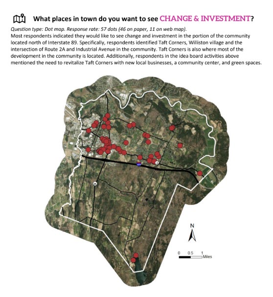
Figure 1: Public engagement dot map results. Results combine both the printed maps from the Roundtable events and the online interactive survey maps.
Recent Changes in Land Use Regulation in Williston
Williston's land use rules have been "conventional" until recently, dividing land areas by allowed and prohibited uses, then later adding design standards and site development standards to zones in Taft Corners and the "Gateway" districts along Routes 2 & 2A and Exit 12 of I-89. In 2022, the adoption of the Taft Corners Form-Based Code represented a shift in focus to what buildings look like and how they are arranged on their sites, emphasizing form over use and intensity of use. These changes removed "units/acre" residential density caps and allowed a much broader set of uses of land in the district, focusing instead on form.
A similar strategy was implemented in the Village Zoning District. In April 2025, new design and development standards for Williston Village were adopted. These standards relaxed residential density caps but put much more emphasis on (and regulation of) how buildings are located on their sites and building design. Design standards stress compatibility with the Williston Village National Register Historic District.
Since 2016, Williston has also changed its zoning to encourage the provision of more affordable homes in new residential projects by requiring the inclusion of some perpetually affordable homes in most new residential developments. This is discussed in greater depth in Chapter 6: Homes and Smart Growth.
External Factors Affecting Williston's Land Use Planning since 2016
Changes in state law limiting the authority of municipalities have also occurred since the adoption of the last Town Plan, altering the "tools in the toolbox" available to Williston when it regulates land use.1 Generally, the ability for Vermont municipalities to require low residential densities and restrict multifamily dwellings has been curtailed by a series of amendments to State statutes that allow them to implement zoning. As of the drafting of this plan, municipalities must allow duplex homes everywhere that single-unit dwellings are allowed, must allow four-plex homes everywhere single-unit dwellings are allowed and water and sewer service is available, and must allow a residential density of at least five dwellings per acre wherever residential uses are allowed and water and sewer service is available. For the purposes of density, a multiunit building up to 4 dwelling units is treated the same as a single unit dwelling. In several cases, these statewide preemptions have had the effect of increasing allowed residential densities and permitted development types beyond the limits Williston had previously established in its zoning.
24 V.S.A §4410-§4427 contain the provisions that identify permissible and prohibited restrictions on the use of land that may be adopted by Vermont municipalities in their zoning. These were changed by Act 47 (The HOME Act) in 2023, and Act 181 (The BE HOME Act) in 2024.
Land Use Trends in Williston
Since the adoption of the 2016 Town Plan, the Planning Commission has interacted with landowners and neighbors in various land use areas as they encountered challenges posed by the existing zoning. In some parts of town, legacy land use patterns mean that sometimes industrial and residential properties are next to each other or even mixed in together. Longstanding businesses on busy corners are sometimes located in zoning districts that only allow residential uses, imposing nonconforming status on them and severely limiting their ability to evolve over time. The nature of some businesses has changed with the advent of online shopping or direct-to consumer service delivery, meaning that some uses that would have been thought of as "downtown" uses 30 years ago now make more sense in an industrial park. The need for outpatient medical services has expanded beyond the typical doctor's office or hospital to a more "office park" configuration.
Other recent trends include:
- Continued residential focus on the Growth Center, with more than 70% of new dwellings in Williston built within its boundaries. The majority of units have been developed in multifamily configurations2. This trend is expected to continue with permitted projects under construction (such as Cottonwood Crossing and the Annex) as well as new buildings designed and permitted under Form-Based Code.
- The Park and Ride and new State Police Barracks in Gateway Zoning District South are the first new developments in that district since a major zoning overhaul in 2009. These two projects, while state projects and partially exempt from Williston's bylaws, mostly comply with the development standards of the Williston bylaw such as lighting, landscaping, access and parking, but also reflect impractical and weak standards for hillside development.3
- The Gateway West area (centered on Williston Road and North/South Brownell Road intersection) was established in 2015. Although this zoning district was created from what was previously zoned Residential, only one parcel has significantly redeveloped since the zoning was changed. Conflicts with air traffic noise at the nearby airport, as well as industrial uses along Commerce Street and farther west on Williston Road, are reasons to reconsider the density, design, and use of this highly trafficked area near some of Williston's more affordable and older neighborhoods.
- Continued diversification of uses and adaptive reuse of sites and buildings in industrial parts of Williston. There is very little undeveloped land remaining in the Industrial West area at this point, but ample opportunities for infill, adaptive reuse, and redevelopment.
- A change in ownership from International Business Machines (IBM) to Global Foundries on parcels in the Industrial East Zoning District, with Chittenden Solid Waste District (CSWD) building or expanding several new waste management facilities in their portion of the area (Materials Recovery Facility, Transfer Station, Metals recycling, Compost Facility).
- With the approval of the Summer Field subdivision on a 30-acre parcel and the Glaser Specific Plan Subdivision on a 96-acre parcel, very few parcels of significant size or development capability remain in Williston's suburban residential area between I-89 and Mountain View Road.
- A very slow rate of growth and change in Williston's rural areas. Very few new houses, no large new subdivisions. Since October 2005, Williston has required subdivisions in the Agricultural/Rural Residential Zoning District to set aside 75% land area as open space. By land area, there is more acreage of protected open space than total land area within the Growth Center.
These trends will help shape the work of the Planning Commission to address bylaw changes and evaluations called for in the Objectives, Strategies and Actions that follow.
Town of Williston (2022). Growth Center Designation 15-year Report. Accessed 4/17/2025 at https://www.town.williston.vt.us/vertical/sites/%7BF506B13C-605B-4878-8062-87E5927E49F0%7D/uploads/Williston_Growth_Center_15-Year_Review_Report_October_28_2022(2).pdf.
Town of Williston Unified Development Bylaw, Chapter 34 Gateway Zoning District South, 34.8 Hillside Development. Accessed 4/17/2025 at https://www.town.williston.vt.us/vertical/sites/%7BF506B13C-605B-4878-8062-87E5927E49F0%7D/uploads/WDB_Jun_04_2024_Chapter_34_Gateway_Zoning_District_South.pdf.
Objectives, Strategies and Actions
Objectives
16.A
16.B
Maintain the viability of industrial and heavy commercial areas in Williston as markets and demands change and buildings and sites age.
16.C
Evaluate the future of the Residential Zoning District for enhanced design review and existing or corner commercial uses.
16.D
The Town will conduct a consistent, transparent, publicly accessible and efficient permit review and approval process.
Strategies
16.1
In addition to land use boundaries as discussed in Chapter 15, evaluate other regulatory solutions for areas where incompatible uses are near residential neighborhoods, such as:
16.1.1
Evaluate land use regulations at the Residential Zoning District and Industrial Zoning District near Commerce Street, Kirby Lane, and South Brownell Road.
16.1.2
Evaluate land use regulations at the Residential Zoning District and Industrial Zoning District near Industrial Ave and North Brownell Road intersection.
16.1.3
Evaluate land use regulations at the Gateway Zoning District North and Residential Zoning District near James Brown Drive and Shirley Circle.
16.1.4
Evaluate land use regulations in other locations mentioned in Chapter 15.
16.2
Evaluate performance and examine the design review standards in the Industrial Zoning Districts.
16.2.1
Evaluate higher design and performance standards for properties with frontage on Williston Road, Industrial Ave, and other arterial and collector roads.
16.2.2
Evaluate a different methodology for allowed and prohibited uses besides NAICS Code.
16.3
Examine performance and reevaluate the landscaping and outdoor lighting standards.
16.3.1
Evaluate landscaping standards for outdoor storage and loading areas, in addition to parking lots to provide shade, stormwater and green strips along buildings and parking lots in industrial and heavy commercial areas.
16.3.2
Evaluate the allowed and prohibited species and explore landscaping standards that enhance wildlife travel corridors, pollinators, native and edible species in all contexts.
16.3.3
Develop Landscape Buffer standards to allow for taller berms, front yard planting minimum densities, and better buffering to provide habitat and pollinator connectivity.
16.3.4
Develop a landscape standard that works in concert with the Conservation Areas and habitat, especially in residential open space subdivisions to reduce lawns and enhance biophilic design principles.
16.3.5
Evaluate and revise outdoor lighting standards to balance public safety with human and wildlife health in consideration of the Dark Sky best practices.
16.3.6
Develop an outreach program to encourage compliance with lighting, landscaping, and other standards of the bylaw.
16.4
Support a broader diversity of uses and intensities in the Industrial Zoning Districts.
16.4.1
Develop amendments to Williston's zoning bylaws to allow more diverse uses in the Industrial Zoning District West, such as space-intensive indoor recreation and greater flexibility for on-site retail sale of manufactured goods, medical services, and others.
16.5
Evaluate revised design and development standards in the Residential Zoning District.
16.5.1
Evaluate "corner commercial" standards to allow existing commercial uses to remain and allow new uses that support a walkable neighborhood pattern.
16.5.2
Evaluate whether to add design standards and requirements for new development in the Residential Zoning District. Standards to consider would be those regulating garage placement and orientation, front doors facing the street, trash and utility consolidation and management in multifamily structures, shared driveway requirements, and others.
16.5.3
Evaluate how to differentiate design and development standards for small infill developments from medium- and large-scale developments.
16.5.4
Evaluate the home business thresholds and limitations in all zoning districts
16.6
Unify the signage regulations for all zoning districts.
16.6.1
Maintain Williston's prohibition of internal and upward illumination everywhere and its prohibition of freestanding signs in the Taft Corners FBC District.
16.6.2
Develop improved signage regulations for buildings and developments in TCFBC that existed prior to the FBC and/or have Master Sign Plans.
16.7
Explore revised design and development standards in the Gateway Zoning Districts North, South, and West as well as Mixed- Use Commercial.
16.7.1
Evaluate the performance of existing standards.
16.7.2
Evaluate ways to encourage adaptive reuse and infill development through revised development standards.
16.7.3
Evaluate how to change allowed and prohibited uses and residential density standards to support economically and socially resilient economies and compatible mixed- use areas.
16.8
Evaluate and modify the provisions for non-conformity thresholds.
16.8.1
Evaluate better integrated standards for existing buildings and developments in the TCFBC Zoning District.
16.8.2
Evaluate standards for when the nature and extent of a non-conforming use can change, particularly in the Residential Zoning District and Agricultural Rural Zoning District.
16.9
Evaluate the permit review process and improve its functionality.
16.9.1
Evaluate the performance of the procedural elements of Williston's Unified development Bylaw (WDB) and revise the thresholds for pre-application, discretionary permit and administrative permit to balance efficiency and public input.
16.9.2
Support ending the duplicative permitting for development served by municipal water and sewer. To ensure that a wastewater system has been installed as designed, as-built plans must be filed with the Zoning Administrator prior to issuance of a certificate of compliance.
16.9.3
Evaluate how to more fully align the Public Works Specifications and Zoning Bylaw.
16.9.4
Evaluate delegating all historic and design review responsibilities to the Development Review Board and/or Zoning Administrator, eliminating the advisory role of the Historic and Design Advisory Committee (HDAC).
16.9.5
Develop a policy proposal to designate the Development Review Board (DRB) as the historic preservation review commission pursuant to the Vermont Historic preservation (VHP) Rule 3.
16.9.6
Evaluate the role and charge of the Historic and Design Advisory Committee (HDAC) such as including or creating a separate Economic and Cultural Development Committee in alignment with Chapter 2 Objectives.
16.10
Monitor the performance of the 2025 Village Zoning District Bylaw Amendments.
16.10.1
Evaluate the performance of the updated development standards in the Village Zoning District (VZD). Within 2 years of adoption, identify areas for improvement and revision to better support the goals of this town plan and the 2018 Master Plan.
16.10.2
Evaluate expanding Village-specific standards into other districts or town-wide.