The location of Williston's Future Land Use and Zoning boundaries are fully in support of the Vision and Goals of the 2025 Williston Comprehensive Plan.
Chapter 15
Future Land Use Boundaries
Introduction
Designating different places where a variety of types and intensities of use are envisioned is often the foundation of a Comprehensive Plan. Land uses that are incompatible with one another are separated, more intense uses are planned where infrastructure can support them, and together these designated places are meant to comprise a cohesive "whole." Districts with development and use rules that align with the Future Land Use designations are the building blocks of the regulatory implementation of the Comprehensive Plan, the Town's zoning. The zoning of the Town is regulated by the Williston Unified Development Bylaw.
This chapter is about how the Town is divided into the land use designations that inform the boundaries of its zoning districts. It identifies areas where changes should be made, either to the borders of the zones themselves or the development standards within them.
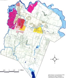
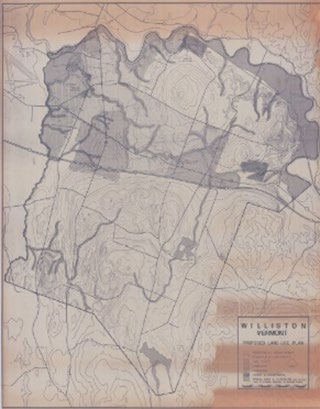
Williston's land use designations and zoning boundaries have been quite stable over the last 40 years, considering the amount of change the Town has seen in that time. The concept of a commercial and mixed-use core at Taft Corners with an industrial area to the west and a suburban area to the north and east, all surrounded by a large low-density agricultural area south of Interstate 89 and north of Mountain View Road harks back to early planning efforts. This overall pattern is proposed by this plan to be maintained, with only minor shifts in zoning boundaries to achieve specific goals.
Particularly, this plan maintains the boundaries of rural Williston and does not propose adding development density or intensity to the parts of the town that have been designated for agriculture and low-density rural residential development throughout Williston's history.
Goals: In 2050, Williston is...
»»
Livable
...because where Williston faces significant "friction" between more and less intense uses on either side of a zoning or Future Land Use map boundary, the Town will take great care to ensure negative impacts on existing residents will be mitigated when those properties are developed or when boundaries are proposed to be shifted.
»»
Resilient
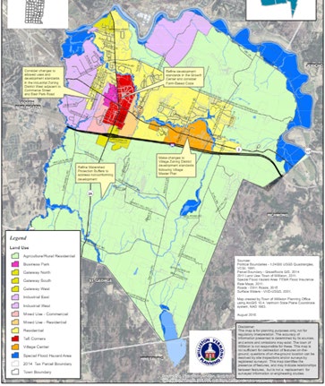
...because the Town will plan proactively to assess and respond to requests to shift the boundaries of the Future Land Use map and zoning districts based on the realities of its geography and current buildout. Particular areas of Town where the Planning Commission expects to review and potentially revise Future Land Use and zoning boundaries are identified in the maps that are adopted along with this Comprehensive Plan.
»»
Equitable
... because when considering both the allowed land uses within zoning districts and the boundaries between them, the Town will strive to ensure that any changes to allowed uses or boundaries do not result in a negative impact to people who are least equipped to endure those impacts. Often residential areas that are closer to commercial or industrial areas are some of the most affordable parts of Town. Similarly, small businesses and agricultural enterprises may be located in areas where zoning has traditionally been used to "squeeze them out" of expensive residential areas. This plan recognizes that responsiveness to the needs of some property owners (relating to changing zoning standards or boundaries) must be balanced with mitigating impacts to vulnerable populations.
Three Things to Know
1
WILLISTON'S LAND USE BOUNDARIES HAVE BEEN REMARKABLY STABLE OVER THE LAST 60 YEARS
... considering the amount of change the town has seen in that time. The concept of a commercial and mixed-use core at Taft Corners with an industrial area to the west and a suburban residential area to the north and east, all surrounded by a large low-density agricultural area south of I-89 and north of Mountain View Road harks back to early planning efforts.
2
HOWEVER, ARCHITECTURAL, DENSITY, AND SITE DESIGN STANDARDS HAVE CHANGED WITHIN THOSE LAND USE DESIGNATIONS
Williston's zoning is constantly evolving, both in response to changes in state law (for example, requirements in 2023 that the Town allow greater residential densities in areas served by water and sewer) and as the Town fine-tunes its development standards to achieve the vision of the Comprehensive Plan (as evidenced by recent work on the Form-Based Code in Taft Corners and bylaw amendment for Williston Village).
3
CHANGING DESIGNATION BOUNDARIES HAS BEEN A CHALLENGE IN SOME PARTS OF TOWN
In parts of Williston where heavy commercial or industrial zoning districts are next to rural and residential areas, there is more friction when a landowner wishes to expand a more intense land use into an area that was formerly rural or residential. While generally Williston's zoning and land use maps have designated land uses in a way that does not put the most intense land uses in direct contact with the least intense ones, there are places where the Town's geography makes that unavoidable. Residential areas abutting Commerce Street, Route 2A, Industrial Avenue, Hurricane Lane, and Brownell Road are all examples of this.
Three Things Public Engagement Told Us
1
WILLISTON'S PEOPLE VALUE THE BALANCE OF RURAL AND SUBURBAN LAND USES
Throughout the Williston 2050 engagement process, people said that they valued the balance Williston has found in maintaining rural land uses in a rural state, while growing and adding density in its commercial and mixed-use areas.
2
WILLISTON'S PEOPLE GENERALLY AGREE WITH THE CURRENT LOCATIONS OF LAND USE BOUNDARIES
While some participants in Williston 2050 acknowledged that keeping rural lands zoned for very few uses and low densities may exclude some housing and economic development, there was little public call to change boundaries in Williston to "open up" more land for denser residential or more intense commercial, industrial, or mixed-use development.
3
WILLISTON'S PEOPLE ARE GENERALLY ACCEPTING OF EXISTING NON-CONFORMING USES WITHIN ITS ZONING DISTRICTS
Throughout the Town, there are commercial uses in the residential areas, industrial uses in mixed-use commercial areas, and even residential uses in industrial areas that have been there since before the zoning prohibited them (legal nonconforming uses, in zoning parlance). There was no significant public desire expressed to make these existing uses "conforming" (that is, relocate them to a different zoning district) during Williston 2050 and some acknowledge that this existing diversity of uses, even where no longer legal under zoning, is an asset to the Town.
Balance of Rural and Suburban Land Uses
Throughout the public engagement process for this Comprehensive Plan, people had very little to say about the boundaries between land use designations in Williston. As these boundaries are more or less invisible, this isn't a surprise. However, people had a lot to say about what they like and didn't like about Williston and what they hoped for in Williston's future that is grounded in the critical planning tool of zoning districts. Citizens value the balance of land uses in Williston, the quiet of its rural and suburban residential places, the community focus of its historic village, and the convenience of having places to work and shop in town. People value keeping property taxes low, which is largely a function of the sales tax revenue Williston collects in its industrial and retail areas. Willistonians don't want to see sprawl. They want to see the more intense development at Taft Corners contained within the boundaries of the Form-Based Code District, and they emphatically want to "keep the rural, rural" due to concern that the town will lose its rural character. These values are reflected in this chapter.
Vision: Land use in Williston is all about BALANCE and CONSISTENCY
Land in Williston is used in a broad diversity of ways, from farming and forestry, to industry, hospitality, and retail, from multi-story apartments to rural homes and large acreages. All these things can coexist in this small Vermont town because they have been arranged spatially with great care using sound planning principles. The Vision for Land Use Boundaries in Williston discussed in this Plan and fulfilled in part by the Goals, Objectives, Strategies, and Actions below is that this great level of care will continue to be employed by the municipality. Minor adjustments will be made to the land use boundaries and the standards within those boundaries to further this vision. By and large, however, no major changes will be made to the boundaries between rural areas and growth areas, recognizing that some of Williston's greatest successes in planning have come from its stalwart consistency. Visions take a long time to become reality, and the consistency of Williston's land use vision over the last half century can be seen and felt around the town. Rural feels like rural, there are no strip malls in Williston Village, and the "grid streets" imagined in Taft Corners in the 1990 Town Plan are beginning to be built. Williston will consistently maintain the geographic balance of its land uses while remaining just flexible enough to adapt to changing conditions.
Compatibility with Neighboring Municipalities
CITY OF ESSEX JUNCTION
The City of Essex Junction adopted its current Comprehensive Plan as the Village of Essex Junction on August 13. 2019. Williston and the City of Essex Junction share a portion of the Winooski River as a municipal boundary and are connected via Route 2A and its bridge over the river. The future land uses in Essex Junction along Williston's border include agricultural, residential, mixed commercial and light industrial, which are compatible with the land uses on the Williston side. Williston and Essex Junction, along with the Town of Essex, share the wastewater treatment capacity of the City of Essex Junction Water Resource Recovery Facility via the "Tri-Town" organization. The Plans for these two communities are compatible.
TOWN OF ESSEX
The Town of Essex adopted its current Comprehensive Plan on March 5, 2024. The two communities share a portion of the Winooski River as a municipal boundary and are connected by North Williston Rd. The boundary is largely floodplain on both sides of the Winooski River. Williston and Essex share similar and comparable goals for watershed and floodplain conservation. Essex states: "to reduce the risk of flood damage to infrastructure and improved property, Essex needs to avoid new development in floodplains, river corridors, land adjacent to streams, wetlands and upland forests, all of which can absorb storm water and reduce flood damage." In Essex, areas just beyond the floodplain feature a combination of Agricultural, Industrial, and Low and Medium Density Residential land use areas. The Plans for these two communities are compatible.
TOWN OF JERICHO
The Town of Jericho adopted its current Comprehensive Plan on December 19, 2023. The two communities share a portion of the Winooski River as a municipal boundary but have no land or bridge connections. The boundary is largely floodplain on both sides of the Winooski River. Williston and Jericho share similar and comparable goals for watershed and floodplain conservation. The land uses in Jericho along the shared boundary are Agricultural Conservation and Natural Resources Protection, while in Williston the land uses are Agricultural. Jericho states: "The Natural Resource Protection Area is dedicated to protecting large contiguous blocks of forested habitat, working forest lands, and surface water networks. This area also includes smaller and more localized areas that host significant, unique, and irreplaceable natural areas and features that add to the diversity and distinctiveness of our community. Future development in this area should be limited to natural resource protection and forest management, passive outdoor recreational activities, and very scattered housing" and "The Agriculture Conservation Area is dedicated to maintaining and conserving working agricultural lands and land that still retains the potential for future agricultural use. Future development in this area should be limited to agricultural uses and activities and scattered rural residential housing." The Plans for these two communities are compatible.
TOWN OF RICHMOND
The Town of Richmond adopted its current Comprehensive Plan on November 6, 2018. Williston's southeastern boundary borders Richmond. The two communities are connected by Route 2 and I-89. The boundary is largely forested along a ridge, with agricultural fields along its northern section. The "Richmond Ridge" is considered regionally important wildlife habitat. In Richmond, this area is designated as a Significant Natural Area. Richmond states: "Portions of High Priority Contiguous Habitat Units, High Priority Forest Blocks, and Habitat Connectors. These areas are found in Richmond's northeast quadrant, eastern and southern borders, southwest border and Bryant Hill. They have been defined by state and regional mapping efforts. Current uses are conserved lands, low density residential, and agricultural and forestry uses, with some accessory uses such as cottage industries and home-based businesses. (Richmond will) minimize forest and habitat connector fragmentation and protect significant natural resources and the ecological services they provide.
These areas will have the lowest density of development in Richmond." The Plans for these two communities are compatible.
TOWN OF HINESBURG
The Town of Hinesburg adopted its current Comprehensive Plan on July 7, 2021. Williston's boundary abuts Hinesburg at Lake Iroquois and the surrounding shorelands, where the shared boundary slices through the middle of Lake Iroquois. Williston adopted the Lake Iroquois Shoreland Protection Area overlay district in 2014, which includes all lands within 250 feet of the mean high-water level of the lake and establishes development standards consistent with the state Shoreland Protection Act. Hinesburg has established a Shoreline Zoning District rather than an overlay. Hinesburg states, "Planning Commission has discussed a variety of possible zoning changes to better ensure water quality and the health of the lakes. One idea is the creation of a lake watershed overlay district to extend design standards (e.g. erosion control, driveway specifications, etc.) and protections beyond the immediate shoreline to all the areas that drain to the lakes. Modifying the boundaries of the Shoreline zoning district has also been discussed. The Shoreland Protection Act enacted in July 2014 created a State permit process to regulate development within 250 feet of lake shorelines. Any revisions to Hinesburg's shoreline land use area and regulations should be carefully dovetailed with the State's regulations." The standards for these abutting land uses are compatible and the Plans for the two communities are compatible.
TOWN OF SAINT GEORGE
The Town of Saint George adopted its Comprehensive Plan on February 15, 2018. Saint George borders Williston along Williston's southwestern boundary. The two communities are connected by Route 2A. The land uses along the shared border are compatible: in Williston, the Agricultural Rural Residential Zoning District and in Saint George, the Rural, Forested Uplands and East Side Residential planning areas Each town is planning for low-density development along the shared border. Both towns are working to preserve the rural character by protecting open space through the use of cluster development policy. Both towns coordinate conservation efforts through membership in the Champlain Valley Conservation Partnership. The Plans for these two communities are compatible.
TOWN OF SHELBURNE
The Town of Shelburne adopted its current Comprehensive Plan on February 12, 2019. Shelburne borders Williston along a small portion of Williston's southwestern boundary. The communities are directly connected by Route 116. Along their shared boundary, agricultural uses and low-density residential uses predominate. Shelburne's Town Plan notes, "In Shelburne's rural areas, farms, forests, water resources & viewscapes... add to the visual qualities that contribute to community identity and pride of place as well as a healthy living environment." Williston and Shelburne share the goal of protecting open space with high natural resource value, and both towns implement this goal through use of an Environmental Reserve Fund. Both towns coordinate conservation efforts through membership in the Champlain Valley Conservation Partnership. The Plans for these town communities are compatible.
CITY OF SOUTH BURLINGTON
The City of South Burlington adopted its current Comprehensive Plan on January 29, 2024. Williston borders South Burlington along Muddy Brook between the Shelburne Pond area and the Winooski River, forming Williston's western boundary. The Muddy Brook corridor is buffered by both communities, dividing development on the two sides by a strip of natural resource protection area. Future land use in Williston and South Burlington are generally compatible along their boundary.
North of I-89, both municipalities include lands for commercial and industrial uses, including along Shunpike Road, Marshall/Kimball Ave and Williston Road. In Williston, the Industrial Zoning District West is adjacent to the shared boundary. In South Burlington, the adjacent land use areas are Commercial/Industrial Only or Principally Commercial with Supporting Residential. South Burlington states: "Identify and plan for areas of the city to be reserved exclusively for businesses that must be located away from housing, such as uses with heavy truck traffic and/or 24-hour operation." This is compatible with Williston's industrial land use goals.
South of I-89, Williston's Agricultural Rural Residential Zoning District abuts South Burlington's Southeast Quadrant. In this area both communities prioritize natural resources conservation and rural/low scale residential use, except at the location of the quarry located in South Burlington accessed from Williston. South Burlington's actions for this area are: "Assess and manage interface between human use and wildlife use areas; balance low-scale residential uses, City-wide recreational assets, and environmental protection; continue to support working lands in this area; complete walking network." This is compatible with Williston's agricultural and low-density residential uses along this boundary. South Burlington and Williston collaborate on numerous fronts, including emergency response, transportation corridors, and administration. Both towns coordinate conservation efforts through membership in the Champlain Valley Conservation Partnership. The Plans for these town communities are compatible.
2018 CHITTENDEN COUNTY ECOS PLAN LAND USE PLAN
The Chittenden County Regional Planning Commission adopted the 2018 ECOS Plan on June 20, 2018. The ECOS Plan focuses primarily on smart development in areas planned for growth, investment in our transportation system (including supporting regional programs and connectivity), continued focus on the Building Homes Together campaign, assisting municipalities with enhanced energy planning, reduction in stormwater impairment and improvement in water quality, emergency management planning through All Hazards Mitigation Plan and related plans, supporting municipal efforts to improve community health, coordination between municipalities toward shared goals, monitoring shifting demographics and workforce development. This plan is compatible with the ECOS plan. This Plan focuses on multi-modal transportation connections and investment, focusing growth in Taft Corners and thoughtful infill in our neighborhoods, natural resource protection, renewable energy generation, regulatory and nonregulatory approaches to addressing the housing crisis, hazard mitigation, public safety and emergency management, stormwater and water quality management, and collaboration with our regional partners. The goals of each element of this plan focus on how we can make Williston a more livable, equitable and resilient place.
Coordination with other Designated Areas
Williston's Land Use designations also align and are coordinated with State Designations. The Taft Corners Area is encompassed by a state-designated Growth Center and the historic village contains a Designated Village Center and a National Register Historic District. Under Vermont law, these designated areas come with requirements and offer benefits for the town, non-profits, and businesses. Those areas, as well as other suburban residential areas, are also contained within Williston's Sewer Service Area, which rarely extends into the more rural fringes of town where lower residential densities and few commercial uses are allowed. Williston's coordination of services, infrastructure, open space priorities and development incentives have long been a hallmark of the Town's plans. This plan proposes continuing that pattern.
Objectives, Strategies and Actions
Objectives
15.A
15.B
When boundaries or zoning standards are considered for change, the Town places the utmost importance on doing so via an open, participatory process that allows participation by all stakeholders.
Strategies
15.1
Maintain the balance between rural and suburban, industrial and urban parts of Williston.
15.1.1
Maintain the boundary of the Agricultural/Rural Residential Zoning District (ARZD) and future Land Use designation for the duration of this Comprehensive Plan. "Keep the rural, rural" in Williston. The Town acknowledges that there will be development pressure to expand denser residential zoning into the ARZD and that there are locations (such as along Mountain View Road or Oak Hill Road just south of Interstate 89) where there are "pipes in the ground" and existing infrastructure that could eventually serve greater densities and intensities of development than are planned for or allowed in these areas.
15.1.2
Maintain the boundaries of Williston's Sewer Service Area where they do not extend further into the ARZD. Williston's Sewer Service Area (SSA) as identified in the maps that accompany this Plan, generally does not extend the opportunity to connect to sewer in the ARZD, even when the physical infrastructure is adjacent to its boundary. This Plan states unambiguously that this arrangement is intentional due to the Town's Land Use goals, its longstanding desire to create a walkable, dense Town Center at Taft Corners, and its limited access to the wastewater treatment capacity necessary to achieve those goals. Pursuant to 24. VSA 4303 (42), the Town hereby defines its "area served by water and sewer as ONLY the area within the SSA boundary as shown on the maps that accompany this Plan.
15.2
Carefully evaluate boundary changes where geography and existing uses do not align with land use designations.
15.2.1
Evaluate the possibility of changing zoning boundaries where they do not align with existing land uses or trends or desired redevelopment in some limited areas of Town. Areas not identified in this Plan may also be considered for boundary changes, but only under the Specific Plan option offered in Williston's bylaws. In either case, the Town will do so while maintaining the goals of Livability, Resilience, and Equity as stated in this Chapter and the overall Plan.
15.2.2
Evaluate changes at the outer edges of the Taft Corners Form-Based Code (TCFBC) District, particularly where it abuts the Gateway South and Mixed-Use Commercial Districts in Williston's Growth Center.
15.2.3
Evaluate changes where River Cove Road intersects Route 2A.
15.2.4
Evaluate changes where industrial uses on Commerce Street abut residential uses on Kirby Lane.
15.2.5
Evaluate changes where commercial and industrial uses abut residential uses on North and South Brownell Road.
15.2.6
Evaluate changes where Industrial uses abut mixed-use "Gateway West" uses at Route 2 and North/South Brownell Road.
15.2.7
Evaluate reverting changes made by the 2007 Specific Plan (approved, never developed) that expanded the Gateway South District into the ARZD on Hurricane Lane.
15.2.8
Evaluate changes to the zoning district boundaries between the RZD, ARZD, and VZD in the area along Williston Road east of the Allen Brook and west of French Hill.
15.2.9
Evaluate changes where the Industrial Zoning District West extends into the Special Flood Hazard Area.
15.2.10
Evaluate changes where the Industrial Zoning District East boundaries align with the surrounding Agricultural/Rural Residential Zoning District to reflect constraints and areas that are not suitable for industrial development.