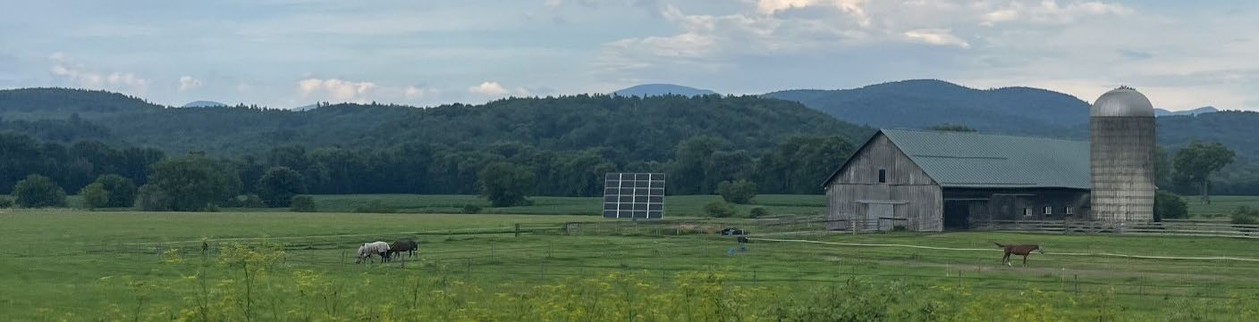
Rural Williston in 2050 looks largely the way it does in 2025, with sparse carefully planned development that clusters homes near roads and preserves open space.
Chapter 17
Rural Land Use & Subdivision Design
Introduction
Williston's rural lands are a core element of the town's history and continue to be a deeply valued resource that contributes to the town's sense of place. Williston has a long history of protecting rural lands for ecological conservation, agriculture, forestry, scenic views and recreation that continues today. As Williston continues to grow, balancing development with support for working landscapes, land conservation, and recreation will become increasingly important because these open space attributes have tremendous value in creating a more livable, equitable, and resilient Williston.
Williston's current land use regulations for residential subdivisions in the Agricultural/Rural Residential Zoning District (ARZD) require low densities and the protection of open space when lots larger than 10.5-acres are subdivided. The intent of these regulations is to balance the landowner's development rights with other stated objectives for Williston's rural areas. In practice, this results in predominantly single-family homes, duplexes, and accessory dwelling units on lots designed to minimize impact to the natural resources within them. Additionally, the regulations also promote the adaptive reuse of historic barns as "wedding barns" or other event venues.
Williston's land use regulations for the Agricultural/Rural Residential Zoning District (ARZD) have remained remarkably consistent since the Town adopted zoning and have contributed to the preservation of the predominantly rural nature of the town that the people of Williston value. Still, there are measures that could be implemented to enhance flexibility for rural landowners and support housing, while strengthening and clarifying natural resource protections.
This chapter discusses existing land use regulations and subdivision design for residential development in rural Williston and how the regulations could be modified to better support the Town's goals. These topics overlap with many related topics such as conservation, working landscapes, and recreation and parks, which are discussed in Chapters 8 and 13.
Goals: In 2050, Williston is...
»»
Livable
Rural Williston is livable for wildlife as well as humans because clustered subdivision design standards with protected open space ensure wildlife travel corridors and the preservation of valuable natural resources.
»»
Resilient
...because a substantial portion of rural land is protected, allowing wildlife and native plants to flourish. Williston maintains stringent subdivision and development standards, which limits sprawl and protects habitat integrity and contiguity.
»»
Equitable
...because even though residential development in rural Williston is expensive due to market conditions and stringent regulations, all Willistonians and visitors to the town have access to rural trails and open spaces that are connected by bicycle and pedestrian path networks. Farm businesses and landowners have created additional gathering places and shared open spaces available to all.
Three Things to Know
1
WILLISTON'S RURAL LANDS ARE CENTRAL TO ITS HISTORY AND CONTINUE TO BE A DEEPLY VALUED RESOURCE THAT CONTRIBUTES TO THE TOWN'S SENSE OF PLACE
Williston has a long history of protecting rural lands for ecological conservation, agriculture, forestry, and recreation that continues today.
2
CURRENT LAND USE REGULATIONS BALANCE PROTECTION OF OPEN SPACE WITH PROPERTY RIGHTS
Williston's current land use regulations for residential development in the Agricultural/Rural Residential Zoning District (ARZD) require low densities and the protection of open space when lots larger than 10.5-acres are subdivided. The intent of these regulations is to balance landowner development rights with the protection of Williston's natural resources and rural character.
3
CONCENTRATING GROWTH IN THE GROWTH CENTER ALIGNS WITH PRESERVING THE RURAL CHARACTER OF WILLISTON OUTSIDE THE SEWER SERVICE AREA
The Town is best positioned to meet its goal of preserving its rural character if it concentrates new development in Taft Corners and continues to limit development in the ARZD. The town can do this by maintaining the current Sewer Service Area, not expanding it or allowing connections outside the boundary; maintaining the current boundary of the ARZD, not shrinking it; maintaining stringent open space development standards in the ARZD and encouraging adaptive reuse of historic barns.
Three Things Public Engagement Told Us
1
Williston's People Value The Balance Of The Dense Center And The Rural Feel Of Most Of The Town
At roundtables and in the survey, there was very strong support for land conservation, trails, country parks, and general support for rural Williston to 'stay the way it is.' Many people appreciate living in a rural town while also enjoying the convenience of living close to cultural amenities, shopping, and restaurants.
2
Protected Open Space Development Patterns In Rural Williston Should Be Maintained
79% of respondents value the preservation of forests and meadows in Williston's open spaces and undeveloped areas.
3
Cycling And Walking On Rural Roads Should Be Safer
The people of Williston requested bike lanes on major roads and pedestrian connectivity between Town-owned parcels. 27% of survey respondents named insufficient bicycle and pedestrian facilities as the Town's top challenge in transportation.
Protecting Natural Resources through Land Use Regulations
Despite past development patterns that have fragmented wildlife habitats in Williston and surrounding communities, significant areas of habitat remain that are essential for a variety of plant and animal species, that contribute to local biological diversity and ecological integrity, and that support traditional activities such as hunting and fishing. Maintaining connectivity through the protection of wildlife habitat and travel corridors is critical to the long-term survival of several wildlife species. Public engagement told us that Williston's people appreciate the presence of wildlife in their town, as well as the many other benefits of ecologically intact landscapes.
One way the Town protects lands with high natural resource value is through its land use regulations, in balance with property rights. Depending on their location and scale, proposed developments
located within conservation areas may be asked to set at least some portion of those areas aside as open space. This is required for subdivisions in the ARZD on parcels with an area of 10.5 acres or greater and encouraged in the RZD.
Approximately 1,484 acres of open space have been protected through Williston's development review requirements. 933 acres of open space has been protected by Williston's 75% open space requirement in the Agriculture/Rural Zoning District (ARZD) and an additional 551 acres of open space has been protected in all other zoning districts.
A suite of regulations in Williston Development Bylaw (WDB) Chapter 27 ensures strong protection of wetland and riparian conservation areas as well as forested upland areas. Wetlands and riparian corridors are protected from incompatible development by the town's stormwater management and watershed health regulations, and other state and federal regulations. Forested uplands are partially protected from incompatible development by the town's WDB Chapter 27 and Chapter 31 regulations.
Beginning in 2005, the Town has taken steps to identify and protect significant wildlife habitat, comprised of core habitat and wildlife corridors:
- 2005 - Several areas characterized as significant habitat were identified in An Assessment of Wildlife Habitat in Williston, VT1
- 2011 - A follow-up study was completed, An Assessment of Wildlife Habitat in Williston: Expanded Land Cover Mapping and Corridor Modeling2
- 2014 - The definition of significant wildlife habitat area (SWHA) and associated map was incorporated in the town's Unified Development Bylaw together with appropriate habitat protection standards as an overlay district. Proposed developments that are within the mapped SWHA are required to document no undue adverse impact to the SWHA through the completion of a Habitat Disturbance Assessment.3
- 2018 - The Town updated language regarding forest fragmentation and worked with the Vermont Department of Fish and Wildlife, Community Conservation Planning staff to refine the Town's Significant Wildlife Habitat Area map, dividing the mapped areas into Tier I (highest priority), Tier II (medium priority) and Tier III (lowest priority). This was done to recognize the importance of forests, in compliance with Act 1714, which encourages and allows municipalities to address protection of forest blocks and habitat connectors. The revised map has not yet been integrated into the Town's regulations.
- 2023 - The Town adopted a bylaw amendment that requires Habitat Disturbance Assessments to be funded by the applicant but completed by a qualified consultant hired by the Town, whereas previously, applicants hired their own consultant to conduct the HDA.
The Strategies and Actions called for in this chapter emphasize continued protection of natural resources, continued updating of maps and data used to inform those protections, evaluating the effectiveness of current regulations and adapting as needed, and coordination with neighboring communities on the protection of natural resources.
Capen, David et al. University of Vermont, Rubenstein School of Environment and Natural Resources, Spatial Analysis Laboratory. 2005. An Assessment of Wildlife Habitat in Williston, Vermont. Accessed 4/15/2025 at https://www.town.williston.vt.us/vertical/Sites/%7BF506B13C-605B-4878-8062-87E5927E49F0%7D/uploads/%7B4C496729-348F-4E34-8728-C01CBB5419CC%7D.PDF.
MacFaden, Sean et al. University of Vermont, Rubenstein School of Environment and Natural Resources, Spatial Analysis Laboratory. 2011. An Assessment of Wildlife Habitat in Williston, Vermont: Expanded Land Cover Modeling and Corridor Modeling. Accessed 4/15/2025 at https://www.town.williston.vt.us/vertical/Sites/%7BF506B13C-605B-4878-8062-87E5927E49F0%7D/uploads/WillistonWildlifeHabitatAnalysis2011_FinalReport.pdf.
Town of Williston Unified Development Bylaw. Chapter 27 – Conservation Areas. Accessed 4/15/2025 at https://www.town.williston.vt.us/vertical/sites/%7BF506B13C-605B-4878-8062-87E5927E49F0%7D/uploads/WDB_Jun_04_2024_Chapter_27_Conservation_Areas.pdf
Vermont Agency of Natural Resources. Act 171 and Planning for Forest Blocks and Habitat Connectors. Accessed 4/15/2025 at https://anr.vermont.gov/act171_forestplanning.
Recent Development Trends in the Agricultural-Rural Residential Zoning District (ARZD)
Recent trends related to development in the ARZD are noted as follows:
- It is becoming very challenging and costly to construct homes in the ARZD, primarily due to the expense of providing onsite wastewater treatment systems and potable water supply systems, as well as a lack of suitable soils for onsite wastewater treatment and a lack of adequate groundwater for potable water systems. Other factors that add to the cost of building a home in the ARZD include needing to construct a longer driveway (for the owner's preference and to avoid neighbor appeals), and compliance with town and state regulations in an area of town where there are more natural resource constraints than in other areas and more stringent natural resource protections. The demand for growth management allocation5 has been very low in the ARZD for several years. There have been only a few projects competing for allocation each year where the annual growth target is 10 homes.6
- Prior to the "small projects exemption" adopted in 2023, all proposed residential subdivisions regardless of size were required to obtain growth management allocation. This had the effect of slowing down development and discouraging small projects, effectively shuttering development in the ARZD. The current regulations exempt from growth management projects with 4 or less dwelling units. This may encourage more proposals for small subdivisions, which could boost housing construction but might increase sprawl.
- Some legacy parcels of large acreage and with dwellings that predate Williston's zoning regulations are initiating "clean up" projects to clarify boundaries and ownership. Often this involves farm properties that are passing to the next generation or otherwise transitioning. This could be a precursor to future development of these working lands.
- Some recent subdivisions involving parcels just over 10.5 acres have used a Boundary Line Adjustment to avoid triggering the 10.5-acre threshold for the 75% open space requirement. That may be due to the fact that Williston's open space requirements have become more stringent – open space must be platted as a separate parcel (an amendment adopted in 2018).
Town of Williston Unified Development Bylaw. Chapter 11 – Including Affordable Homes and Residential Growth Management. Accessed 4/15/2025 at https://www.town.williston.vt.us/vertical/sites/%7BF506B13C-605B-4878-8062-87E5927E49F0%7D/uploads/WDB_Jun_04_2024_Chapter_11_Including_Affordable_Homes_and_Residential_Growth_Management.pdf.
New Homes and People: 5-Year Outlook – Predicted Residential and Commercial Growth FY26-30. Memorandum from Williston Planning Staff to Williston Selectboard. November 19, 2024. Accessed 2/28/2025 at Agenda Packet - November 19, 2024 - Selectboard Meetings 2024 - Town of Williston, Vermont
Recent Changes in State Law
Act 250 is undergoing a transition period. Act 181 affected a major overhaul of the Act 250 regulatory framework, where jurisdiction will no longer be determined by the project size, rather by location. Projects within areas planned for growth in the Regional Future Land Use map will benefit from Act 250 exemptions if Williston obtains Tier 1A and 1B status for areas within it that are planned growth areas.7 However, status in the ARZD (a Tier 2 area) will be unchanged from what exists today.
Given recent trends, we can expect to perhaps see more small subdivisions in the ARZD and very few large subdivisions. To help protect the rural landscape of Williston and support working land uses, the Strategies and Actions call for the Town to consider allowing more flexible uses in the ARZD to support working farms as they diversify their operations, and to evaluate allowing more allowed uses for historic barns, including farmworker housing.
State of Vermont Act 250. A New Land Use Review Framework (Act 181). Accessed 4/15/2025 at https://act250.vermont.gov/new-land-use-review-framework-act-181.
Objectives, Strategies and Actions
Objectives
17.A
17.B
Rural Williston has large swaths of protected open space with invaluable attributes like wetlands, upland forests, farmland, and scenic vistas.
17.C
Rural Williston has thriving local farms that support the local food system and make it more resilient. Williston's land-use regulations support the continued operation of local farms.
Strategies
17.1
Focus development within the growth center and limit development in the Agricultural Rural Residential Zoning district (ARZD).
17.1.1
Maintain the boundaries of the ARZD for the duration of this plan, except where explicitly called for evaluation in other chapters.
17.1.2
Maintain the boundaries of the sewer service area and do not extend sewer lines outside of the area, except in response to public health emergencies.
17.1.3
Evaluate the removal of or revision to the Transfer of Development Rights provisions in the Williston Development Bylaw as it is largely no longer applicable given unlimited allowed density in the Taft Corners Form Based Code District.
17.2
Continue to require low residential density and open space protection in the ARZD.
17.2.1
Maintain, at minimum, the required protection of 75% open space for parcels larger than 10.5 acres in the ARZD.
17.2.2
Evaluate the 10.5-acre threshold for open space and the 75% open space requirement to see whether smaller acreages should also be subject to some open space requirement.
17.2.3
Evaluate requiring development to be clustered closer to existing roads to further reduce habitat fragmentation.
17.3
Continue to protect Significant Wildlife Habitat Areas, areas containing uncommon, rare, threatened, or endangered species, unique natural communities, farmlands of local importance, scenic viewsheds, special flood hazard areas, and streams, wetlands, lakes, and ponds during the development review process.
17.3.1
Maintain the requirement for Habitat Disturbance Assessments as a component of development review to ensure the protection of the above stated resources during the development review process.
17.3.2
Evaluate the HDA process to determine if it is adequately protecting the natural resources it seeks to protect.
17.3.3
Maintain the data and maps used to make decisions about the protection of natural resources.
17.3.4
Develop coordination with neighboring communities on the preservation of natural resources in the development review process.
17.4
Evaluate and amend land use regulations and other town policies to protect natural resources, support working landscapes, and respond to changing economic and environmental climates.
17.4.1
Evaluate and revise land use regulations to allow a diverse range of uses to support working landscapes such as agriculture and on-farm businesses, fee-based recreation, hospitality, and educational activities.
17.4.2
Evaluate and revise the visual resource protection standards of the WDB Chapter 27, including an update to the 1980 Visual Resource Assessment Map. Prioritize important views through Official Map.
17.4.3
Evaluate and revise the important farmland protection standards of the WDB Chapter 27, particularly the use of the LESA map.
17.4.4
Implement revisions to the zoning district specific standards – particularly Chapters 31 Agricultural Rural Residential Zoning District (ARZD) and 39 Residential Zoning District (RZD)—based on the conservation area and water health standards of Chapter 27 and 29.
17.4.5
Evaluate and amend land use regulations to strengthen habitat protections, Habitat Disturbance Assessments, mitigation measures, and right-size protections for small- and infill-projects. Include past land disturbance and land use history in the habitat or watershed health protection value.
17.4.6
Incorporate the revised Significant Wildlife Habitat Area map into the WDB Chapter 27 standards.
17.5
Support the adaptive reuse of historic barns because they contribute to Williston's rural character.
17.5.1
Evaluate broadening the list of allowed uses for historic barns to promote their conservation and adaptive reuse and to support Williston's working landscapes
17.5.2
Develop relaxed density provisions to allow historic barns to be used for farmworker housing.
17.6
Explore new land use regulations that support diversifying farms and small businesses.
17.6.1
Develop land use regulations that allow more public events in rural Williston.
17.6.2
Develop land use regulations that support and promote safe housing for farm workers.
17.6.3
Evaluate amending land use regulations to allow camping and other necessary ordinances or town policies to support camping and reduce nuisances.